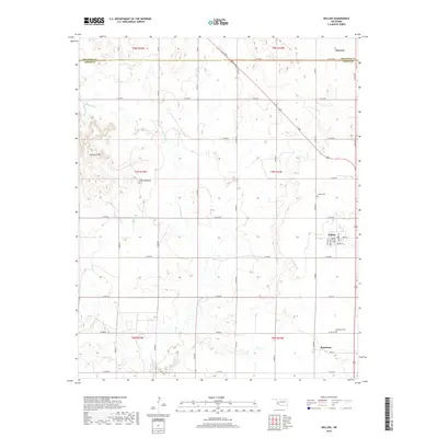
2018 Map of Willow
USGS Topo · Published 2018About this map
Willow and Brinkman anchor the southeastern corner of this Greer County landscape, where the grid of rural section roads meets the natural drainage of Lake Cr. To the north, the terrain transitions into the heights of Haystack Mtn and the landmark known as The Haystack, which rise above the winding path of Haystack Cr. This 2018 survey reveals the persistent settlement pattern of the Oklahoma plains, showing the continued importance of local centers and the proximity of the Willow Cem and Brinkman Cem to their namesake communities. The northern boundary is defined by the Co Line Rd separating Greer and Beckham counties, while the settlement of Moravia sits just across this line in the northeastern corner. The map captures a meticulously organized agricultural landscape defined by roads such as E1350 Rd and N1920 Rd, connecting isolated farmsteads to the regional thoroughfares.
Find a feature on this map
40 named features on this map. Tap any name to fly to it.
Don’t see what you’re looking for? This feature index may not catch every label — zoom into the map to look around manually.
Map Details
Editions of this 2018 Willow Map
This is the sole edition of this map. No revisions or reprints were ever made.
Other maps of this area

1955 · Lawton
USGS Topo · 1:250,000

1955 · Clinton
USGS Topo · 1:250,000

1957 · Clinton
USGS Topo · 1:250,000

1961 · Willow
USGS Topo · 1:62,500

1961 · Retrop
USGS Topo · 1:62,500

1971 · Mangum North
USGS Topo · 1:24,000

1971 · Granite
USGS Topo · 1:24,000

1971 · Reed
USGS Topo · 1:24,000

1985 · Elk City
USGS Topo · 1:100,000

1985 · Altus
USGS Topo · 1:100,000