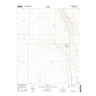
2014 Map of Willow Springs
USGS Topo · Published 2014About this map
Hidden Springs Mission sits at the foot of the Echo Cliffs in this modern survey of the Painted Desert region. The landscape is defined by the sharp verticality of Hamblin Ridge and the winding course of Hamblin Wash, which parallels the modern corridor of Us-89. Water sources are the critical landmarks for this high-desert environment, with numerous named points including Blue Spring, Government Spring, and Jack Homer Spring dotting the base of the cliffs. The settlement at Willow Springs represents a localized hub of activity, where the desert floor meets the rising sandstone formations. The map also records the Bureau of Indian Affairs road network, including Bia-6133 and Bia-23, providing a clear record of modern accessibility and land management within the reservation boundaries.
Find a feature on this map
19 named features on this map. Tap any name to fly to it.
Don’t see what you’re looking for? This feature index may not catch every label — zoom into the map to look around manually.
Map Details
Editions of this 2014 Willow Springs Map
This is the sole edition of this map. No revisions or reprints were ever made.
Other maps of this area

1886 · Echo Cliffs
USGS Topo · 1:250,000

1891 · Echo Cliffs
USGS Topo · 1:250,000

1954 · Shinumo Altar SE
USGS Topo · 1:24,000

1954 · Shinumo Altar
USGS Topo · 1:62,500

1955 · Blue Spring NE
USGS Topo · 1:24,000
1955 · Blue Spring SE
USGS Topo · 1:24,000

1955 · Moa Ave NW
USGS Topo · 1:24,000
1955 · Moa Ave SW
USGS Topo · 1:24,000

1955 · Blue Spring
USGS Topo · 1:62,500

1956 · Marble Canyon
USGS Topo · 1:250,000