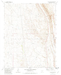
1981 Map of Willow Springs
USGS Topo · Published 1982About this map
Navajo Indian Reservation lands dominate this high-desert landscape, defined by the striking topographic rise of the Echo Cliffs running along the eastern boundary. The presence of the Hidden Springs Mission and scattered Ruins near Willow Creek points to a history of pastoral activity and community outposts in a territory where water is the primary currency. Natural water sources are the defining landmarks here, with names like Jack Homer Spring, Government Spring, and Rose Spring marking the intermittent drainages of Hamblin Wash. Evidence of small-scale exploration appears at Prospects in the southern reaches, while a lonely Corral reflects the area's continued use for livestock within the reservation boundaries. This 1981 survey documents a sparsely populated but deeply utilized terrain where human presence is tethered to rare springs and historical mission work.
Find a feature on this map
15 named features on this map. Tap any name to fly to it.
Don’t see what you’re looking for? This feature index may not catch every label — zoom into the map to look around manually.
Map Details
Editions of this 1981 Willow Springs Map
This is the sole edition of this map. No revisions or reprints were ever made.
Other maps of this area

1886 · Echo Cliffs
USGS Topo · 1:250,000

1891 · Echo Cliffs
USGS Topo · 1:250,000

1954 · Shinumo Altar SE
USGS Topo · 1:24,000

1954 · Shinumo Altar
USGS Topo · 1:62,500

1955 · Blue Spring NE
USGS Topo · 1:24,000
1955 · Blue Spring SE
USGS Topo · 1:24,000

1955 · Moa Ave NW
USGS Topo · 1:24,000
1955 · Moa Ave SW
USGS Topo · 1:24,000

1955 · Blue Spring
USGS Topo · 1:62,500

1956 · Marble Canyon
USGS Topo · 1:250,000