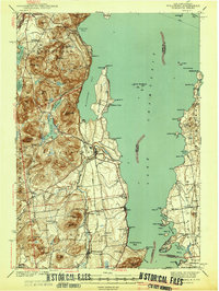
1941 Map of Willsboro
USGS Topo · Published 1941About this map
The Lake Champlain shoreline in the late 1930s is defined by its strategic transportation corridors and rugged lakeside geography. On the western shore, the Delaware and Hudson railroad tracks trace the base of the mountains, connecting Willsboro and Essex to the interior. This survey reveals a landscape where seasonal recreation and permanent settlement converge at places like Craterclub and Willsboro Point.
Find a feature on this map
108 named features on this map. Tap any name to fly to it.
Don’t see what you’re looking for? This feature index may not catch every label — zoom into the map to look around manually.
Map Details
Editions of this 1941 Willsboro Map
2 editions found

Other maps of this area

1894 · Elizabethtown
USGS Topo · 1:62,500

1894 · Port Henry
USGS Topo · 1:62,500

1894 · Plattsburg
USGS Topo · 1:62,500

1895 · Willsboro
USGS Topo · 1:62,500

1895 · Elizabethtown
USGS Topo · 1:62,500

1895 · Ausable
USGS Topo · 1:62,500

1898 · Port Henry
USGS Topo · 1:62,500

1901 · Elizabethtown
USGS Topo · 1:62,500

1903 · Ausable
USGS Topo · 1:62,500

1903 · Middlebury
USGS Topo · 1:62,500