
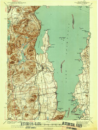
1941 Map of Willsboro
USGS Topo · Published 1941About this map
Lake Champlain dominates this 1941 survey, captured just before the mid-century shift in local transport and rural education. The eastern shore in Vermont shows the Rutland railroad line serving Charlotte, while across the water in New York, the Delaware and Hudson railroad parallels the coast through Willsboro and Whallonsburg. This era retains a high density of rural schoolhouses, including the Ryan Sch, Brookfield Sch, and Whallon Bay Sch, reflecting a landscape of small, self-contained communities before district consolidation.
Find a feature on this map
114 named features on this map. Tap any name to fly to it.
Don’t see what you’re looking for? This feature index may not catch every label — zoom into the map to look around manually.
Map Details
Editions of this 1941 Willsboro Map
2 editions found
Other maps of this area

1894 · Elizabethtown
USGS Topo · 1:62,500

1894 · Port Henry
USGS Topo · 1:62,500

1894 · Plattsburg
USGS Topo · 1:62,500

1895 · Willsboro
USGS Topo · 1:62,500

1895 · Elizabethtown
USGS Topo · 1:62,500

1895 · Ausable
USGS Topo · 1:62,500

1898 · Port Henry
USGS Topo · 1:62,500

1901 · Elizabethtown
USGS Topo · 1:62,500

1903 · Ausable
USGS Topo · 1:62,500

1903 · Middlebury
USGS Topo · 1:62,500