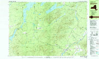
1978 Map of Wilmington
USGS Topo · Published 1979About this map
Whiteface Mountain and the Stephenson Range dominate this landscape within the Adirondack Park during the late 1970s. The village of Wilmington serves as a local hub near the West Branch Ausable River, while the specialized community of North Pole sits at the base of the mountain. The mapping captures a network of industrial and recreational history, including the Memorial Highway ascending the peak and various gravel pits scattered near Forestdale.
Find a feature on this map
92 named features on this map. Tap any name to fly to it.
Don’t see what you’re looking for? This feature index may not catch every label — zoom into the map to look around manually.
Map Details
Editions of this 1978 Wilmington Map
This is the sole edition of this map. No revisions or reprints were ever made.
Other maps of this area

1895 · Ausable
USGS Topo · 1:62,500

1896 · Lake Placid
USGS Topo · 1:62,500

1898 · Lake Placid
USGS Topo · 1:62,500

1902 · Saranac
USGS Topo · 1:62,500

1903 · Ausable
USGS Topo · 1:62,500

1904 · Saranac
USGS Topo · 1:62,500

1906 · Loon Lake
USGS Topo · 1:62,500

1908 · Loon Lake
USGS Topo · 1:62,500

1911 · Lyon Mountain
USGS Topo · 1:62,500

1913 · Dannemora
USGS Topo · 1:62,500