1965 Map of Wilmington
USGS Topo · Published 1979About this map
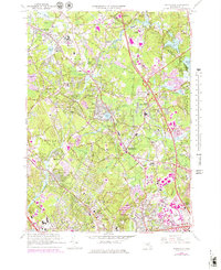
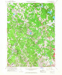
The Shawsheen River meanders through this landscape of the Middlesex County suburbs during a period of rapid mid-century expansion. The complex of the Tewksbury State Hospital, accompanied by the State Hospital Cem, serves as a major local landmark alongside the established village centers of Tewksbury and Wilmington. The industrial and transit legacy of the region is evident in the numerous Gravel Pits dotting the terrain and the corridors of the Boston and Maine railroad.
Find a feature on this map
73 named features on this map. Tap any name to fly to it.
Don’t see what you’re looking for? This feature index may not catch every label — zoom into the map to look around manually.
Map Details
Editions of this 1965 Wilmington Map
2 editions found
Other maps of this area

1886 · Lawrence
USGS Topo · 1:62,500

1886 · Lowell
USGS Topo · 1:62,500

1886 · Framingham
USGS Topo · 1:62,500

1888 · Lawrence
USGS Topo · 1:62,500

1889 · Framingham
USGS Topo · 1:62,500

1893 · Lowell
USGS Topo · 1:62,500

1893 · Boston
USGS Topo · 1:62,500

1893 · Lawrence
USGS Topo · 1:62,500

1894 · Framingham
USGS Topo · 1:62,500

1903 · Boston
USGS Topo · 1:62,500