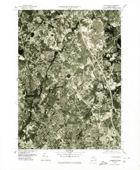
1977 Map of Wilmington
USGS Topo · Published 1980About this map
Wilmington and its surrounding suburban landscape are captured here in a late 1970s orthophotograph, a period marked by significant residential expansion in Middlesex County. The imagery reveals the dense network of housing developments and commercial infrastructure that had begun to define towns like Burlington and Woburn. Natural drainage systems such as the Shawsheen River and the Ipswich River provide a sharp contrast to the geometric patterns of modern roads and neighborhoods. Distinct residential pockets like Pinehurst and the community around Silver Lake show the post-war shift toward commuter-centered living. This orthophoto provides a precise visual record of land use before further decades of infill and redevelopment changed these traditional Massachusetts town centers.
Find a feature on this map
8 named features on this map. Tap any name to fly to it.
Don’t see what you’re looking for? This feature index may not catch every label — zoom into the map to look around manually.
Map Details
Editions of this 1977 Wilmington Map
This is the sole edition of this map. No revisions or reprints were ever made.
Other maps of this area

1886 · Lawrence
USGS Topo · 1:62,500

1886 · Lowell
USGS Topo · 1:62,500

1886 · Framingham
USGS Topo · 1:62,500

1888 · Lawrence
USGS Topo · 1:62,500

1889 · Framingham
USGS Topo · 1:62,500

1893 · Lowell
USGS Topo · 1:62,500

1893 · Boston
USGS Topo · 1:62,500

1893 · Lawrence
USGS Topo · 1:62,500

1894 · Framingham
USGS Topo · 1:62,500

1903 · Boston
USGS Topo · 1:62,500