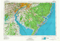
1966 Map of Wilmington
USGS Topo · Published 1968About this map
The Delaware River corridor serves as the industrial and urban backbone of this mid-century landscape, anchoring the major metropolitan hubs of Wilmington, Philadelphia, and Camden. While the northern and western sections show dense development and a complex network of rail lines like the Pennsylvania Railroad and Reading Railroad, the southern and coastal reaches remain remarkably open. Immense protected areas like the Wharton State Forest and Bombay Hook National Wildlife Refuge define the character of the Pine Barrens and the wetlands along Delaware Bay.
Find a feature on this map
75 named features on this map. Tap any name to fly to it.
Don’t see what you’re looking for? This feature index may not catch every label — zoom into the map to look around manually.
Map Details
Editions of this 1966 Wilmington Map
4 editions found
Other maps of this area

1884 · Sea Isle
USGS Topo · 1:62,500

1884 · Whitings
USGS Topo · 1:62,500

1887 · Atlantic City
USGS Topo · 1:62,500

1888 · Bordentown
USGS Topo · 1:62,500

1888 · Pemberton
USGS Topo · 1:62,500

1888 · Barnegat
USGS Topo · 1:62,500

1888 · Cape May
USGS Topo · 1:62,500

1888 · Dennisville
USGS Topo · 1:62,500

1888 · Little Egg Harbor
USGS Topo · 1:62,500

1888 · Mount Holly
USGS Topo · 1:62,500