1993 Map of Wilmington North
USGS Topo · Published 1993About this map
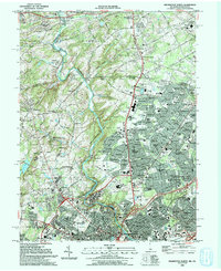
Brandywine Creek meanders through this landscape, serving as a focal point for both industrial heritage and preserved natural spaces in the early 1990s. The map illustrates the dense cluster of cultural institutions along the corridor, including the Winterthur Museum and Gardens and the Hagley Museum. This area, bridging the Pennsylvania and Delaware border, shows a transition from the historic battlefield sites of Brandywine Battlefield State Park in the north to the suburban expansion around Wilmington.
Find a feature on this map
121 named features on this map. Tap any name to fly to it.
Don’t see what you’re looking for? This feature index may not catch every label — zoom into the map to look around manually.
Map Details
Editions of this 1993 Wilmington North Map
2 editions found
Other maps of this area

1890 · Salem
USGS Topo · 1:62,500

1894 · Chester
USGS Topo · 1:62,500

1896 · Chester
USGS Topo · 1:62,500

1898 · Salem
USGS Topo · 1:62,500

1898 · Chester
USGS Topo · 1:62,500

1901 · Camden
USGS Topo · 1:125,000

1901 · West Chester
USGS Topo · 1:62,500

1904 · West Chester
USGS Topo · 1:62,500

1904 · Wilmington
USGS Topo · 1:62,500

1906 · Wilmington
USGS Topo · 1:62,500