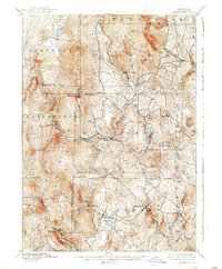
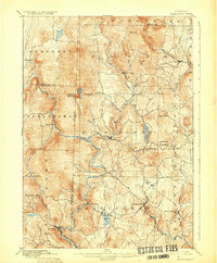
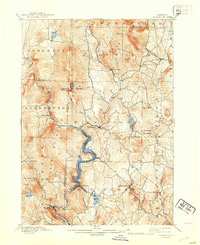
1899 Map of Wilmington
USGS Topo · Published 1938About this map
The Deerfield River carves a deep path through these southern Vermont uplands, dictating the settlement patterns and transport routes of the late nineteenth century. The Hoosac Tunnel and Wilmington R.R. follows the river's winding course through the mountains, connecting the industrial hub of Readsboro with points north. This rail corridor was essential for the movement of timber and goods through a landscape dominated by the high ridges of Haystack Mountain and Hogback Mountain.
Find a feature on this map
51 named features on this map. Tap any name to fly to it.
Don’t see what you’re looking for? This feature index may not catch every label — zoom into the map to look around manually.
Map Details
Editions of this 1899 Wilmington Map
3 editions found
Other maps of this area

1886 · Greylock
USGS Topo · 1:62,500

1886 · Hawley
USGS Topo · 1:62,500

1889 · Wilmington
USGS Topo · 1:62,500

1890 · Hawley
USGS Topo · 1:62,500

1890 · Greenfield
USGS Topo · 1:62,500

1891 · Wilmington
USGS Topo · 1:62,500

1891 · Greylock
USGS Topo · 1:62,500

1891 · Brattleboro
USGS Topo · 1:62,500

1893 · Brattleboro
USGS Topo · 1:62,500

1893 · Greylock
USGS Topo · 1:62,500