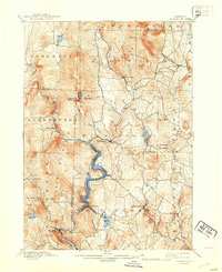
1899 Map of Wilmington
USGS Topo · Published 1942About this map
The Deerfield River forms the central spine of this topographic landscape, flowing southward past Wilmington and through the valley that would later be transformed by hydroelectric development. This 1942 reprint of an 1889 survey captures the transition of the region, featuring the newly recorded Whitingham Lake along with the older settlement patterns of Whitingham and Jacksonville. The industrial and transportation needs of the late 19th century are evident in the path of the Hoosac Tunnel and Wilmington R.R., which snakes along the river toward Readsboro and the tunnel to the south. Prominent peaks like Haystack Mountain and Hogback Mountain define the high country of the Green Mountain National Forest, while smaller hamlets like Heartwellville and Davis Bridge illustrate the scattered community life of the Windham and Bennington county borders before major mid-century changes.
Find a feature on this map
53 named features on this map. Tap any name to fly to it.
Don’t see what you’re looking for? This feature index may not catch every label — zoom into the map to look around manually.
Map Details
Editions of this 1899 Wilmington Map
3 editions found

Other maps of this area

1886 · Greylock
USGS Topo · 1:62,500

1886 · Hawley
USGS Topo · 1:62,500

1889 · Wilmington
USGS Topo · 1:62,500

1890 · Hawley
USGS Topo · 1:62,500

1890 · Greenfield
USGS Topo · 1:62,500

1891 · Wilmington
USGS Topo · 1:62,500

1891 · Greylock
USGS Topo · 1:62,500

1891 · Brattleboro
USGS Topo · 1:62,500

1893 · Brattleboro
USGS Topo · 1:62,500

1893 · Greylock
USGS Topo · 1:62,500