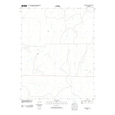
2009 Map of Wilmore SE
USGS Topo · Published 2009About this map
Red Hills dominates the northern portion of this Comanche County landscape, where the high plains of Kansas transition into more dissected terrain. The drainage network is dense and complex, defined by the winding course of Mule Creek and its many tributaries, including Widow Creek and Dunlap Creek. This area is characterized by landforms like Baker Canyon, which highlights the erosional processes shaping the region's distinct topography. Modern transportation corridors are established along the southern and central sections, with US Hwy 160 cutting a straight east-west path across the lower portion of the sheet. Further north, the namesake Sun City Rd provides access through the higher elevations. The map reveals a rural expanse where water sources like Horse Creek and Walnut Creek have historically dictated the placement of roads and early ranching boundaries.
Find a feature on this map
12 named features on this map. Tap any name to fly to it.
Don’t see what you’re looking for? This feature index may not catch every label — zoom into the map to look around manually.
Map Details
Editions of this 2009 Wilmore SE Map
This is the sole edition of this map. No revisions or reprints were ever made.
Other maps of this area

1891 · Medicine Lodge
USGS Topo · 1:125,000

1892 · Coldwater
USGS Topo · 1:125,000

1893 · Medicine Lodge
USGS Topo · 1:125,000

1955 · Pratt
USGS Topo · 1:250,000

1959 · Pratt
USGS Topo · 1:250,000

1968 · Sun City SW
USGS Topo · 1:24,000
1968 · Sun City
USGS Topo · 1:24,000

1968 · Wilmore SE
USGS Topo · 1:24,000

1968 · Belvidere
USGS Topo · 1:24,000
1973 · Deerhead
USGS Topo · 1:24,000