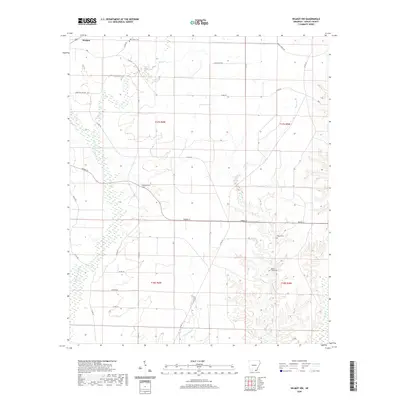
2020 Map of Wilmot NW
USGS Topo · Published 2020About this map
Wallace and its surrounding agricultural lands define this section of Ashley County, where the landscape is marked by a network of drainage systems and rural burial grounds. The territory is defined by the winding paths of several waterways, including Haley Cr in the north and the extensive Beech Cr system to the east. These creeks carve through the terrain, influencing the placement of early road networks like Emma Wallace Rd and Parker St. For researchers of local heritage, the map identifies several significant rural interments, such as the New Texas Cem near the northern boundary and the Beech Creek Cem situated along its namesake creek. The surveyor’s grid reveals a transition from the structured farm plots near Cleveland Cem to the wetlands bordering Chemin-a-Haut Cr and Overflow Cr.
Find a feature on this map
32 named features on this map. Tap any name to fly to it.
Don’t see what you’re looking for? This feature index may not catch every label — zoom into the map to look around manually.
Map Details
Editions of this 2020 Wilmot NW Map
This is the sole edition of this map. No revisions or reprints were ever made.
Other maps of this area

1935 · Mist
USGS Topo · 1:62,500

1935 · Wilmot
USGS Topo · 1:62,500

1952 · Fountain Hill
USGS Topo · 1:24,000

1953 · Greenwood
USGS Topo · 1:250,000

1956 · Greenwood
USGS Topo · 1:250,000

1960 · Snyder
USGS Topo · 1:24,000

1960 · Mist
USGS Topo · 1:62,500

1960 · Wilmot
USGS Topo · 1:62,500
1960 · Portland
USGS Topo · 1:24,000

1960 · Wilmot NW
USGS Topo · 1:24,000