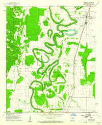
1960 Map of Portland
USGS Topo · Published 1961About this map
Bayou Bartholomew snakes in extreme meanders through this portion of Ashley County, defining a landscape of oxbow lakes and remnant brakes. The settlement of Portland sits at the northeastern corner, where the Missouri Pacific railroad runs parallel to the bayou's general course. This era shows a distributed rural community connected by small churches and schools, such as Tillis High Sch and New Light Ch. The map's detail extends to the complex hydrology of the Delta, naming features like Wilson Brake, Anthony Lake, and St Marion Brake, which illustrate the slow-moving drainage patterns of the region. To the south, the village of Parkdale marks the rail line near Union Ch, while the interior is dotted with remote landmarks like Holly Grove Ch and its associated cemetery, revealing the localized centers of social life in the mid-20th century.
Find a feature on this map
32 named features on this map. Tap any name to fly to it.
Don’t see what you’re looking for? This feature index may not catch every label — zoom into the map to look around manually.
Map Details
Editions of this 1960 Portland Map
2 editions found
Other maps of this area

1935 · Mist
USGS Topo · 1:62,500

1935 · Wilmot
USGS Topo · 1:62,500

1936 · Eudora
USGS Topo · 1:62,500

1936 · Lake Village
USGS Topo · 1:62,500

1953 · Greenwood
USGS Topo · 1:250,000

1955 · Lake Village
USGS Topo · 1:62,500

1956 · Greenwood
USGS Topo · 1:250,000

1957 · Eudora
USGS Topo · 1:62,500

1960 · Snyder
USGS Topo · 1:24,000

1960 · Mist
USGS Topo · 1:62,500