
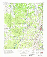
1957 Map of Eudora
USGS Topo · Published 1957About this map
Eudora serves as the primary hub in this mid-century survey of the Mississippi River Delta's lower reaches, where the complex hydrology of Chicot County is on full display. The landscape is defined by an intricate network of waterways, including the winding Boeuf River, Macon Bayou, and Lafourche Lake, which dictate the placement of rural settlements and agricultural boundaries. The map reveals a dense social infrastructure of small community centers, often anchored by institutions such as Bright Morning Star Ch and the Ross Van Ness Sch.
Find a feature on this map
50 named features on this map. Tap any name to fly to it.
Don’t see what you’re looking for? This feature index may not catch every label — zoom into the map to look around manually.
Map Details
Editions of this 1957 Eudora Map
2 editions found
Other maps of this area

1909 · Millikin
USGS Topo · 1:24,000

1909 · Ashton Bridge
USGS Topo · 1:24,000

1912 · Ashton Bridge
USGS Topo · 1:31,680

1935 · Mist
USGS Topo · 1:62,500

1935 · Wilmot
USGS Topo · 1:62,500

1935 · Oak Grove
USGS Topo · 1:62,500

1935 · Bonita
USGS Topo · 1:62,500

1936 · Eudora
USGS Topo · 1:62,500

1936 · Lake Village
USGS Topo · 1:62,500

1939 · Readland
USGS Topo · 1:62,500