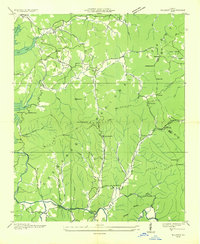
1935 Map of Wilscot
USGS Topo · Published 1935About this map
Star Creek Mill and the emerging recreational sites of Lake Toccoa anchor this survey of the Fannin and Union county borderlands. Conducted just as the Tennessee Valley Authority was reshaping the region's hydrology, the map documents a landscape transitioning from traditional mountain agriculture to state-managed conservation. Rural life centers on small communities like Dial and Morganton, with numerous country churches such as Concord Ch and Pleasant Hill Ch serving as focal points for local families.
Find a feature on this map
64 named features on this map. Tap any name to fly to it.
Don’t see what you’re looking for? This feature index may not catch every label — zoom into the map to look around manually.
Map Details
Editions of this 1935 Wilscot Map
This is the sole edition of this map. No revisions or reprints were ever made.
Other maps of this area

1888 · Ellijay
USGS Topo · 1:125,000

1892 · Ellijay
USGS Topo · 1:125,000

1898 · Ellijay
USGS Topo · 1:125,000

1911 · Ellijay
USGS Topo · 1:125,000

1935 · Ivylog
USGS Topo · 1:24,000

1935 · Mulky Gap
USGS Topo · 1:24,000

1935 · Noontootla
USGS Topo · 1:24,000

1935 · Mineral Bluff
USGS Topo · 1:24,000

1935 · Lake Toccoa
USGS Topo · 1:24,000

1935 · Tickanetley
USGS Topo · 1:24,000