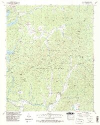
1988 Map of Wilscot
USGS Topo · Published 1988About this map
Morganton sits at the northern edge of this territory where the Blue Ridge Lake reservoir reaches into the mountains. This late-twentieth-century landscape is defined by the dense forest of the Chattahoochee National Forest and the winding course of the Toccoa River. Family names are deeply etched into the geography, seen in features like Picklesimer Mountain, Van Zandt Weeks Creek, and Brawley Mountain. The map provides a detailed view of the rural infrastructure in Fannin County, showing small mountain settlements like Dial, Hurst, and Padena. Cultural landmarks are numerous, including several country churches such as Star Creek Ch and Friendship Ch, alongside a vast network of family cemeteries like the Van Zandt Cem and Brawley Cem. The presence of the Benton MacKaye Trail and the Skeenah Creek Mill illustrates the transition from traditional Appalachian industries to recreational land use during this era.
Find a feature on this map
102 named features on this map. Tap any name to fly to it.
Don’t see what you’re looking for? This feature index may not catch every label — zoom into the map to look around manually.
Map Details
Editions of this 1988 Wilscot Map
3 editions found
Other maps of this area

1888 · Ellijay
USGS Topo · 1:125,000

1892 · Ellijay
USGS Topo · 1:125,000

1898 · Ellijay
USGS Topo · 1:125,000

1911 · Ellijay
USGS Topo · 1:125,000

1935 · Ivylog
USGS Topo · 1:24,000

1935 · Mulky Gap
USGS Topo · 1:24,000

1935 · Noontootla
USGS Topo · 1:24,000

1935 · Mineral Bluff
USGS Topo · 1:24,000

1935 · Lake Toccoa
USGS Topo · 1:24,000

1935 · Tickanetley
USGS Topo · 1:24,000