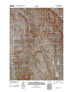
2011 Map of Wilson Butte
USGS Topo · Published 2011About this map
Wilson Butte stands as the central topographic landmark of this Harney County landscape, anchoring a high-desert terrain defined by seasonal water flow and volcanic landforms. The drainage of Wilson Creek cuts through the southwestern corner, reflecting the sparse but critical hydrologic network of this portion of eastern Oregon. Near the western edge, Wildhorse Lake Reservoir provides a primary point of water collection in an otherwise arid expanse. This 2011 survey documents a remote ranching and grazing region where human presence is marked by a network of local roads and 4WD tracks connecting the basin's scattered landmarks.
Find a feature on this map
3 named features on this map. Tap any name to fly to it.
Don’t see what you’re looking for? This feature index may not catch every label — zoom into the map to look around manually.
Map Details
Editions of this 2011 Wilson Butte Map
This is the sole edition of this map. No revisions or reprints were ever made.
Other maps of this area

1955 · Burns
USGS Topo · 1:250,000

1958 · Burns
USGS Topo · 1:250,000

1959 · Burns
USGS Topo · 1:250,000

1980 · Lunch Lake
USGS Topo · 1:24,000
1980 · Flybee Lake
USGS Topo · 1:24,000

1980 · Iron Mtn. Flat
USGS Topo · 1:24,000

1980 · Alec Butte
USGS Topo · 1:24,000

1980 · Lake on The Trail
USGS Topo · 1:24,000
1984 · Dry Valley Rim
USGS Topo · 1:24,000
1984 · Goose Egg Butte
USGS Topo · 1:24,000