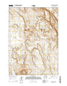
2014 Map of Wilson Butte
USGS Topo · Published 2014About this map
Wilson Butte stands as the primary landmark in this high-desert portion of Harney County, rising above a landscape defined by intermittent water sources and drainage patterns. This 2014 survey documents the hydrography of the region, including the Wildhorse Lake Reservoir and the isolated Lunch Lake. The drainage of Wilson Cr cuts through the southwest, illustrating the arid character of the Oregon interior. The map clearly delineates the Public Land Survey System grid with boundaries for t27s r26e, t27s r27e, t28s r26e, and t28s r27e, which provide a vital framework for land researchers and genealogists tracing property records in this expansive territory. The elevation contours reveal the subtle but significant volcanic topography typical of the northern Great Basin.
Find a feature on this map
8 named features on this map. Tap any name to fly to it.
Don’t see what you’re looking for? This feature index may not catch every label — zoom into the map to look around manually.
Map Details
Editions of this 2014 Wilson Butte Map
This is the sole edition of this map. No revisions or reprints were ever made.
Other maps of this area

1955 · Burns
USGS Topo · 1:250,000

1958 · Burns
USGS Topo · 1:250,000

1959 · Burns
USGS Topo · 1:250,000

1980 · Lunch Lake
USGS Topo · 1:24,000
1980 · Flybee Lake
USGS Topo · 1:24,000

1980 · Iron Mtn. Flat
USGS Topo · 1:24,000

1980 · Alec Butte
USGS Topo · 1:24,000

1980 · Lake on The Trail
USGS Topo · 1:24,000
1984 · Dry Valley Rim
USGS Topo · 1:24,000
1984 · Goose Egg Butte
USGS Topo · 1:24,000