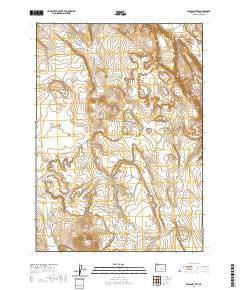
2020 Map of Wilson Butte
USGS Topo · Published 2020About this map
Wilson Butte commands the southern portion of this high-desert landscape in Harney County, serving as a prominent landmark in a region defined by its drainage systems and water management. The presence of the Wildhorse Lake Reservoir in the western section of the sheet illustrates the critical role of water storage in this arid environment, providing a focal point for the surrounding terrain. Tracing through the southern reaches, Wilson Cr winds across the landscape, marking the natural hydrology of the area. This 2020 survey provides a contemporary perspective on the vast public lands and grazing areas of eastern Oregon, where topography is dictated by subtle elevation changes and seasonal watercourses. The grid lines of the Public Land Survey System, including t27s r26e and t28s r27e, organize this open space, which remains largely defined by its natural features rather than dense human settlement.
Find a feature on this map
7 named features on this map. Tap any name to fly to it.
Don’t see what you’re looking for? This feature index may not catch every label — zoom into the map to look around manually.
Map Details
Editions of this 2020 Wilson Butte Map
This is the sole edition of this map. No revisions or reprints were ever made.
Other maps of this area

1955 · Burns
USGS Topo · 1:250,000

1958 · Burns
USGS Topo · 1:250,000

1959 · Burns
USGS Topo · 1:250,000

1980 · Lunch Lake
USGS Topo · 1:24,000
1980 · Flybee Lake
USGS Topo · 1:24,000

1980 · Iron Mtn. Flat
USGS Topo · 1:24,000

1980 · Alec Butte
USGS Topo · 1:24,000

1980 · Lake on The Trail
USGS Topo · 1:24,000
1984 · Dry Valley Rim
USGS Topo · 1:24,000
1984 · Goose Egg Butte
USGS Topo · 1:24,000