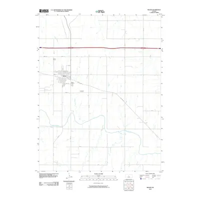
2009 Map of Wilson
USGS Topo · Published 2009About this map
Wilson serves as the central hub of this Ellsworth County landscape, situated where the historic alignment of Old US Hwy 40 meets a grid of rural section roads. The town's layout is clearly defined north of the Smoky Hill River, which meanders across the southern half of the quadrangle. Local history is anchored by the Wilson Cemetery and the Old Wilson Cemetery, providing valuable points of reference for genealogical research. To the northwest, the Wilson Airport marks the edge of the community's footprint. The surrounding terrain is defined by a network of waterways including Wilson Creek, Spring Creek, and Blood Creek, which draw through the plains toward the main river channel. This 2009 survey captures the transition from established town streets to the vast agricultural expanse of central Kansas, highlighting the persistent importance of transportation corridors like the modern interstate and the bypassed sections of the old highway.
Find a feature on this map
33 named features on this map. Tap any name to fly to it.
Don’t see what you’re looking for? This feature index may not catch every label — zoom into the map to look around manually.
Map Details
Editions of this 2009 Wilson Map
This is the sole edition of this map. No revisions or reprints were ever made.
Other maps of this area

1894 · Ellsworth
USGS Topo · 1:125,000

1896 · Russell
USGS Topo · 1:125,000

1955 · Great Bend
USGS Topo · 1:250,000

1956 · Wilson
USGS Topo · 1:24,000

1956 · Dorrance
USGS Topo · 1:24,000

1957 · Great Bend
USGS Topo · 1:250,000

1957 · Holyrood NE
USGS Topo · 1:24,000

1957 · Black Wolf
USGS Topo · 1:24,000

1958 · Great Bend
USGS Topo · 1:250,000
1964 · Wilson NW
USGS Topo · 1:24,000