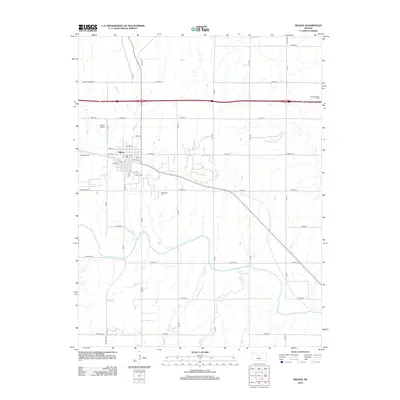
2012 Map of Wilson
USGS Topo · Published 2012About this map
The city of Wilson anchors this landscape in central Kansas, positioned near the northern banks of the winding Smoky Hill River. By the early 21st century, the town's grid is well-established, centered around Saline St and extending toward the Wilson Airport on its western edge. The drainage patterns of the region are defined by several watercourses including Wilson Cr, Coal Cr, and Blood Cr, which carve through the plains to meet the river. Genealogists will find significant local history in the three distinct burial grounds: Wilson Cem, Old Wilson Cem, and Pleasant Valley Cem to the northeast. The map illustrates a transition between the dense residential blocks of the town and the vast network of rural routes such as Homer Bunker Rd and 4 Corners Rd that serve the surrounding agricultural land.
Find a feature on this map
43 named features on this map. Tap any name to fly to it.
Don’t see what you’re looking for? This feature index may not catch every label — zoom into the map to look around manually.
Map Details
Editions of this 2012 Wilson Map
This is the sole edition of this map. No revisions or reprints were ever made.
Other maps of this area

1894 · Ellsworth
USGS Topo · 1:125,000

1896 · Russell
USGS Topo · 1:125,000

1955 · Great Bend
USGS Topo · 1:250,000

1956 · Wilson
USGS Topo · 1:24,000

1956 · Dorrance
USGS Topo · 1:24,000

1957 · Great Bend
USGS Topo · 1:250,000

1957 · Holyrood NE
USGS Topo · 1:24,000

1957 · Black Wolf
USGS Topo · 1:24,000

1958 · Great Bend
USGS Topo · 1:250,000
1964 · Wilson NW
USGS Topo · 1:24,000