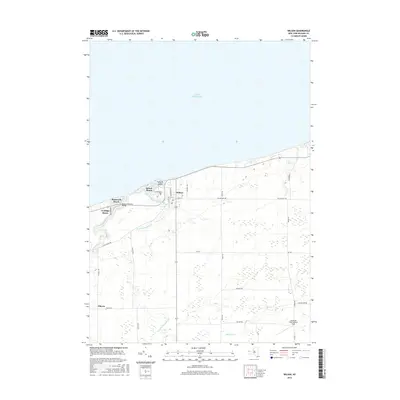
2016 Map of Wilson
USGS Topo · Published 2016About this map
The village of Wilson serves as the focal point of this Niagara County shoreline, where the waters of Lake Ontario meet a landscape shaped by glacial drainage. The map reveals a cluster of lakeside communities including Roosevelt Beach, Sunset Beach, and Coolidge Beach, which developed around the mouth of Twelvemile Creek. A distinct local history is visible in the layout of Tuscarora Bay and its sheltered Tuscarora Island, while the Roosevelt Beach Bridge provides a vital link across the inlet. Further inland, the agricultural character of the region is evident near the settlement of Elberta and along rural corridors like Maple Rd. Researchers can trace local genealogy through the Greenwood Cem and identify historical land use near Hollands International Field and the various branches of the creek system, including Hopkins Cr and the E Br Twelvemile Cr.
Find a feature on this map
34 named features on this map. Tap any name to fly to it.
Don’t see what you’re looking for? This feature index may not catch every label — zoom into the map to look around manually.
Map Details
Editions of this 2016 Wilson Map
This is the sole edition of this map. No revisions or reprints were ever made.
Other maps of this area

1894 · Wilson
USGS Topo · 1:62,500

1897 · Tonawanda
USGS Topo · 1:62,500

1897 · Olcott
USGS Topo · 1:62,500

1897 · Lockport
USGS Topo · 1:62,500

1899 · Niagara
USGS Topo · 1:125,000

1900 · Wilson
USGS Topo · 1:62,500

1900 · Tonawanda
USGS Topo · 1:62,500

1901 · Tonawanda
USGS Topo · 1:62,500

1902 · Lockport
USGS Topo · 1:62,500

1905 · Lockport
USGS Topo · 1:62,500