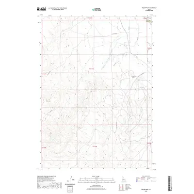
2020 Map of Wilson Peak
USGS Topo · Published 2020About this map
Wilson Peak serves as a prominent landmark in this corner of southwestern Idaho, anchoring a landscape defined by the drainage systems of Reynolds Cr. This 2020 survey illustrates a complex network of local infrastructure, including the Reynolds Cr Bernard Ditch and China Ditch Rd, which speak to the area's agricultural and water management history. The northern edge of the map identifies the jurisdictional boundary between Canyon County and Owyhee County as it crosses Bayha Island. For those researching local families, the Wilson Cem is clearly marked near the intersection of Wilson Creek Rd and Cemetery Ln. The terrain is punctuated by distinctive landforms such as Hemingway Butte and high-elevation ridges like those accessed by Pigeon Rd.
Find a feature on this map
28 named features on this map. Tap any name to fly to it.
Don’t see what you’re looking for? This feature index may not catch every label — zoom into the map to look around manually.
Map Details
Editions of this 2020 Wilson Peak Map
This is the sole edition of this map. No revisions or reprints were ever made.
Other maps of this area

1892 · Silver City
USGS Topo · 1:125,000

1894 · Silver City
USGS Topo · 1:125,000

1898 · Silver City
USGS Topo · 1:125,000

1955 · Boise
USGS Topo · 1:250,000
1957 · Walters Butte
USGS Topo · 1:24,000

1957 · Opalene Gulch
USGS Topo · 1:24,000

1957 · Wilson Peak
USGS Topo · 1:24,000

1957 · Sands Basin
USGS Topo · 1:62,500

1958 · Boise
USGS Topo · 1:250,000
1958 · Givens Hot Springs
USGS Topo · 1:24,000