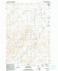
1992 Map of Wilson Peak
USGS Topo · Published 1992About this map
Wilson Peak dominates the landscape of Owyhee County in this 1990s-era topographic survey, standing as a high-altitude landmark above a terrain defined by desert ranching and mining. The area around the Wilson Community Hall and Wilson Cemetery serves as the focal point for this rural community, where water management is critical for survival. A complex network of irrigation, including Bernard Ditch and Nicholson Ditch, draws from natural watercourses to support agricultural operations like the Feedlot near Hemingway Butte. Along the northeastern edge, the Snake River carves the boundary between Canyon and Owyhee counties, flowing past Wright Island and Bayha Island. Evidence of extractive industry is found throughout the hills, where numerous Prospect sites and an Open Pit Mine sit alongside numerous Guzzler installations for wildlife or livestock water.
Find a feature on this map
26 named features on this map. Tap any name to fly to it.
Don’t see what you’re looking for? This feature index may not catch every label — zoom into the map to look around manually.
Map Details
Editions of this 1992 Wilson Peak Map
This is the sole edition of this map. No revisions or reprints were ever made.
Other maps of this area

1892 · Silver City
USGS Topo · 1:125,000

1894 · Silver City
USGS Topo · 1:125,000

1898 · Silver City
USGS Topo · 1:125,000

1955 · Boise
USGS Topo · 1:250,000
1957 · Walters Butte
USGS Topo · 1:24,000

1957 · Opalene Gulch
USGS Topo · 1:24,000

1957 · Wilson Peak
USGS Topo · 1:24,000

1957 · Sands Basin
USGS Topo · 1:62,500

1958 · Boise
USGS Topo · 1:250,000
1958 · Givens Hot Springs
USGS Topo · 1:24,000