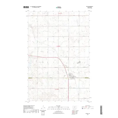
2018 Map of Wilton
USGS Topo · Published 2018About this map
Wilton straddles the boundary of McLean and Burleigh Counties in this 2018 survey, serving as a significant northern plains crossroads where the 83 Loop passes through the town's grid. The settlement is defined by its residential and civic layout, featuring several named avenues such as Minnesota Ave, Bismarck Ave, and Bookwalter Ave. A cluster of religious and commemorative sites east of the town center includes the Sacred Heart, Saints Peter and Paul, and Saint Nicholas cemeteries, indicating the area's deep-rooted community history.
Find a feature on this map
41 named features on this map. Tap any name to fly to it.
Don’t see what you’re looking for? This feature index may not catch every label — zoom into the map to look around manually.
Map Details
Editions of this 2018 Wilton Map
This is the sole edition of this map. No revisions or reprints were ever made.
Other maps of this area

1949 · Turtle Creek
USGS Topo · 1:62,500

1950 · Wilton
USGS Topo · 1:62,500

1954 · McClusky
USGS Topo · 1:250,000

1958 · McClusky
USGS Topo · 1:250,000

1959 · Mercer SW
USGS Topo · 1:24,000

1961 · Turtle Creek SW
USGS Topo · 1:24,000

1961 · Turtle Creek SE
USGS Topo · 1:24,000

1966 · Price
USGS Topo · 1:24,000

1966 · Wilton SE
USGS Topo · 1:24,000
1966 · Sanger
USGS Topo · 1:24,000