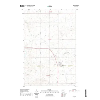
2020 Map of Wilton
USGS Topo · Published 2020About this map
The town of Wilton serves as the central hub of this prairie landscape, straddling the border of McLean Co Burleigh Co. This 2020 survey illustrates a grid of agricultural section lines and rural roads, such as 12th St SW and 14th St SW, that define the region's development. A significant cluster of historical and religious sites is located north and east of the town center, including Sacred Heart Cem, Holy Trinity Orthodox Cem, and Saints Peter and Paul Cem, reflecting the diverse community heritage of the area. The terrain is marked by seasonal drainages like Yanktonai Cr to the west and Burnt Cr to the south. Modern transportation corridors, specifically McLean Co Hwy 41, bisect the landscape, connecting the local residents and farmers to the wider plains of North Dakota.
Find a feature on this map
48 named features on this map. Tap any name to fly to it.
Don’t see what you’re looking for? This feature index may not catch every label — zoom into the map to look around manually.
Map Details
Editions of this 2020 Wilton Map
This is the sole edition of this map. No revisions or reprints were ever made.
Other maps of this area

1949 · Turtle Creek
USGS Topo · 1:62,500

1950 · Wilton
USGS Topo · 1:62,500

1954 · McClusky
USGS Topo · 1:250,000

1958 · McClusky
USGS Topo · 1:250,000

1959 · Mercer SW
USGS Topo · 1:24,000

1961 · Turtle Creek SW
USGS Topo · 1:24,000

1961 · Turtle Creek SE
USGS Topo · 1:24,000

1966 · Price
USGS Topo · 1:24,000

1966 · Wilton SE
USGS Topo · 1:24,000
1966 · Sanger
USGS Topo · 1:24,000