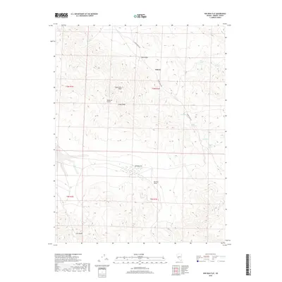
2018 Map of Win Wan Flat
USGS Topo · Published 2018About this map
Midway serves as a lone point of reference in this high-desert region of Mineral County, where the topography is defined by the Gabbs Valley Range and the Gillis Range. The landscape is a network of arid basins and sharp ridges, including Chukar Ridge and Wildhorse Canyon, punctuated by several vital water sources that likely dictated movement through the territory. Named watering holes such as Wild Rose Spring, Whiskey Spring, and Dripping Vat Spring are scattered across the terrain, indicating the historical importance of localized water for ranching or travel.
Find a feature on this map
20 named features on this map. Tap any name to fly to it.
Don’t see what you’re looking for? This feature index may not catch every label — zoom into the map to look around manually.
Map Details
Editions of this 2018 Win Wan Flat Map
This is the sole edition of this map. No revisions or reprints were ever made.
Other maps of this area

1909 · Hawthorne
USGS Topo · 1:250,000

1911 · Hawthorne
USGS Topo · 1:250,000

1915 · Hawthorne
USGS Topo · 1:250,000

1948 · Walker Lake
USGS Topo · 1:250,000

1957 · Walker Lake
USGS Topo · 1:250,000

1962 · Walker Lake
USGS Topo · 1:250,000

1964 · Walker Lake
USGS Topo · 1:250,000
1979 · Copper Mtn.
USGS Topo · 1:24,000
1979 · Indian Head Peak
USGS Topo · 1:24,000
1979 · Ramsey Spring
USGS Topo · 1:24,000