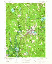
1954 Map of Winchendon
USGS Topo · Published 1965About this map
The industrial and riverine character of northern Worcester County is captured here along the Millers River, where water power once fueled numerous mill ponds and satellite settlements. The village of Winchendon serves as the central hub, surrounded by outlying communities like Winchendon Springs, Waterville, and Bullardville. The landscape is defined by its transition from the New Hampshire border at Lake Monomonac south toward the protected lands of the Otter River State Forest. Local history is preserved in the locations of the Riverside Cem and Marvin Sch, while the Boston and Maine railroad tracks illustrate the transportation network that connected these manufacturing centers to larger markets. From the heights of Mt Pleasant to the lowlands of Lake Denison, the map provides a detailed look at a mid-century New England town balancing industry with its wooded surroundings.
Find a feature on this map
67 named features on this map. Tap any name to fly to it.
Don’t see what you’re looking for? This feature index may not catch every label — zoom into the map to look around manually.
Map Details
Editions of this 1954 Winchendon Map
3 editions found
Other maps of this area

1887 · Winchendon
USGS Topo · 1:62,500

1887 · Fitchburg
USGS Topo · 1:62,500

1889 · Fitchburg
USGS Topo · 1:62,500

1890 · Winchendon
USGS Topo · 1:62,500

1893 · Fitchburg
USGS Topo · 1:62,500

1894 · Winchendon
USGS Topo · 1:62,500

1898 · Monadnock
USGS Topo · 1:62,500

1900 · Peterboro
USGS Topo · 1:62,500

1931 · Fitchburg
USGS Topo · 1:48,000

1932 · Winchendon
USGS Topo · 1:48,000