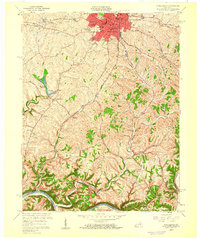
1959 Map of Winchester
USGS Topo · Published 1960About this map
The city of Winchester anchors this late 1950s survey, showing its transition into a regional hub with residential developments like Wesleyan Park and Colby Hills expanding from the core. The landscape to the south and east is defined by the winding paths of Lower Howard Creek and Fourmile Creek, which eventually meet the Kentucky River at the southern map boundary. This area preserves a network of rural schoolhouses and houses of worship central to local genealogy, including the Old Stone Ch, Antioch Ch, and the Hickman St Sch. Transportation infrastructure is prominently featured, with the Chesapeake and Ohio and Louisville and Nashville railroads crossing the terrain. The presence of the Winchester Reservoir and various waterworks indicates the growing municipal needs of the era, while outlying settlements like Elkin and Flanagan maintain their distinct rural character amidst the complex drainage patterns of the Bluegrass region.
Find a feature on this map
53 named features on this map. Tap any name to fly to it.
Don’t see what you’re looking for? This feature index may not catch every label — zoom into the map to look around manually.
Map Details
Editions of this 1959 Winchester Map
This is the sole edition of this map. No revisions or reprints were ever made.
Other maps of this area

1892 · Richmond
USGS Topo · 1:125,000

1897 · Richmond
USGS Topo · 1:125,000

1927 · Lexington
USGS Topo · 1:48,000

1929 · Lexington
USGS Topo · 1:62,500

1952 · Union City
USGS Topo · 1:24,000

1952 · Palmer
USGS Topo · 1:24,000

1952 · Clintonville
USGS Topo · 1:24,000

1952 · Austerlitz
USGS Topo · 1:24,000

1952 · Ford
USGS Topo · 1:24,000

1952 · Winchester
USGS Topo · 1:24,000