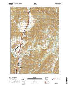
2020 Map of Winchester
USGS Topo · Published 2020About this map
The North Umpqua River carves a path through this Douglas County landscape, serving as a primary geographical anchor between Sutherlin and the northern reaches of Roseburg. The map illustrates a region defined by river-bend settlements and upland terrain, with Winchester situated at a critical crossing near the Winchester Reservoir. Educational and community development is evident at the Umpqua Community College campus along the riverbanks, while the area's older history is preserved at the Wilbur Cem and Otey Cem near the small community of Wilbur. Notable elevations like Winchester Baldy and Echo Butte rise above the drainage basins of Newton Cr and Dixon Cr, showcasing the varied topography that has shaped local infrastructure from Deady Crossing Rd to the suburban expansion of Roseburg North.
Find a feature on this map
80 named features on this map. Tap any name to fly to it.
Don’t see what you’re looking for? This feature index may not catch every label — zoom into the map to look around manually.
Map Details
Editions of this 2020 Winchester Map
This is the sole edition of this map. No revisions or reprints were ever made.
Other maps of this area

1897 · Roseburg
USGS Topo · 1:125,000

1900 · Roseburg
USGS Topo · 1:125,000

1954 · Dixonville
USGS Topo · 1:62,500

1954 · Sutherlin
USGS Topo · 1:62,500

1954 · Glide
USGS Topo · 1:62,500

1955 · Roseburg
USGS Topo · 1:62,500

1958 · Roseburg
USGS Topo · 1:250,000

1959 · Roseburg
USGS Topo · 1:250,000

1979 · Roseburg
USGS Topo · 1:100,000
1987 · Roseburg East
USGS Topo · 1:24,000