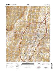
2016 Map of Winchester
USGS Topo · Published 2016About this map
Winchester and the surrounding Shenandoah Valley landscape appear here during a period of modern growth and historical preservation. The city core is dense with commemorative sites, including the Stonewall Confederate Cem, Mount Hebron Cem, and the German Lutheran Church Cem. The presence of Shenandoah Univ and the Winchester Regional Airport highlights the area's development as a regional hub, while the terrain is defined by the prominent Apple Pie Ridge and Little North Mountain to the west.
Find a feature on this map
244 named features on this map. Tap any name to fly to it.
Don’t see what you’re looking for? This feature index may not catch every label — zoom into the map to look around manually.
Map Details
Editions of this 2016 Winchester Map
This is the sole edition of this map. No revisions or reprints were ever made.
Other maps of this area

1894 · Winchester
USGS Topo · 1:125,000

1914 · Gerrardstown
USGS Topo · 1:48,000

1916 · Gerrardstown
USGS Topo · 1:62,500

1916 · Capon Bridge
USGS Topo · 1:62,500

1923 · Middletown
USGS Topo · 1:62,500

1923 · Capon Bridge
USGS Topo · 1:62,500

1937 · Capon Bridge
USGS Topo · 1:48,000

1937 · Gerrardstown
USGS Topo · 1:48,000

1937 · Middletown
USGS Topo · 1:48,000

1938 · Winchester
USGS Topo · 1:48,000