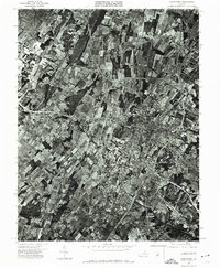
1972 Map of Winchester
USGS Topo · Published 1974About this map
Winchester is captured in this orthophotograph just as the city was undergoing significant expansion in the early 1970s. The aerial imagery, processed by James L. Calver and the Virginia Division of Mineral Resources, reveals a clear contrast between the dense historical street grid of the city center and the sprawling agricultural plots of Frederick County. The intersection of major transportation routes is highly visible, showing how the regional road network was already shaping the outskirts of the town. To the southeast, the Winchester Municipal Airport stands as a focal point of the area's infrastructure, surrounded by a patchwork of wooded lots and open fields. This map provides a unique visual record of land use patterns, showing the transition from a traditional valley town to a modernizing regional hub.
Find a feature on this map
2 named features on this map. Tap any name to fly to it.
Don’t see what you’re looking for? This feature index may not catch every label — zoom into the map to look around manually.
Map Details
Editions of this 1972 Winchester Map
This is the sole edition of this map. No revisions or reprints were ever made.
Other maps of this area

1894 · Winchester
USGS Topo · 1:125,000

1914 · Gerrardstown
USGS Topo · 1:48,000

1916 · Gerrardstown
USGS Topo · 1:62,500

1916 · Capon Bridge
USGS Topo · 1:62,500

1923 · Middletown
USGS Topo · 1:62,500

1923 · Capon Bridge
USGS Topo · 1:62,500

1937 · Capon Bridge
USGS Topo · 1:48,000

1937 · Gerrardstown
USGS Topo · 1:48,000

1937 · Middletown
USGS Topo · 1:48,000

1938 · Winchester
USGS Topo · 1:48,000