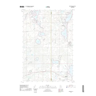
2018 Map of Winchester
USGS Topo · Published 2018About this map
Winchester sits at the heart of this lake-studded landscape on the border of Iron and Vilas counties in the Northwoods of Wisconsin. The terrain is defined by a dense network of glacial water bodies, with the Turtle River winding through the northern reaches near Fisher Lake and Catherine Lake. To the south, the Manitowish River flows through a series of connected waters including Manitowish Waters, Vance Lake, and Rest Lake. This 2018 survey illustrates the recreational and residential development typical of the region, featuring numerous access roads like Fisher Lake Rd and Circle Lily Rd that trace the shorelines. A notable terrestrial landmark is the Railroad Grade 2, which cuts across the central portion of the map, signaling the area's transition from early timber harvesting to its modern character. The map also identifies dozens of smaller basins such as Circle Lily Lake and North Bass Lake, highlighting the intricate hydrology of the Highland Lake District.
Find a feature on this map
79 named features on this map. Tap any name to fly to it.
Don’t see what you’re looking for? This feature index may not catch every label — zoom into the map to look around manually.
Map Details
Editions of this 2018 Winchester Map
This is the sole edition of this map. No revisions or reprints were ever made.
Other maps of this area

1939 · Winchester
USGS Topo · 1:48,000

1940 · Mercer
USGS Topo · 1:48,000

1943 · Ironwood
USGS Topo · 1:48,000

1945 · Mercer
USGS Topo · 1:48,000

1946 · Winchester
USGS Topo · 1:48,000

1947 · Mercer
USGS Topo · 1:48,000

1953 · Ashland
USGS Topo · 1:250,000

1955 · Mercer
USGS Topo · 1:62,500

1955 · Winchester
USGS Topo · 1:62,500

1955 · Wakefield
USGS Topo · 1:62,500