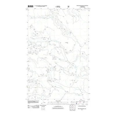
2011 Map of Winchester Peak
USGS Topo · Published 2011About this map
Winchester Peak dominates this drainage basin within the Selkirk Mountains region of Pend Oreille County. The landscape is defined by a dense network of mountain streams, including Small Creek, Graham Creek, and the many branches of North Fork Calispell Creek. These waters flow through a terrain marked by early 21st-century resource extraction and rural infrastructure, centered around Danforth Quarry and the Elliott Dam on the South Fork Small Creek.
Find a feature on this map
20 named features on this map. Tap any name to fly to it.
Don’t see what you’re looking for? This feature index may not catch every label — zoom into the map to look around manually.
Map Details
Editions of this 2011 Winchester Peak Map
This is the sole edition of this map. No revisions or reprints were ever made.
Other maps of this area

1927 · Chewelah
USGS Topo · 1:125,000

1930 · Chewelah
USGS Topo · 1:125,000

1936 · Newport
USGS Topo · 1:96,000

1942 · Newport
USGS Topo · 1:125,000

1958 · Sandpoint
USGS Topo · 1:250,000

1963 · Sandpoint
USGS Topo · 1:250,000
1964 · Calispell Peak
USGS Topo · 1:24,000

1964 · Goddards Peak
USGS Topo · 1:24,000

1964 · Chewelah Mtn
USGS Topo · 1:62,500
1965 · Nelson Peak
USGS Topo · 1:24,000