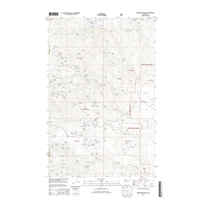
2014 Map of Winchester Peak
USGS Topo · Published 2014About this map
Winchester Peak dominates this section of the Kanisku National Forest, serving as a high-altitude anchor for a complex network of mountain drainage systems. The landscape is defined by the headwaters and divergent forks of major local waterways, including the N Fork Calispell Cr and the Middle Fork Calispell Cr to the south. The rugged geography influenced a timber-centric infrastructure, evidenced by the numerous Forest Service developments such as Nat For Dev Rd 73 and the winding Winchester Creek Rd. Towards the eastern edge, more established local access emerges via Flowery Trail Rd and Danforth Rd, marking the transition from high forest ridges toward the lower valley elevations. Small-scale residential or agricultural footprints appear along named tracks like Scheller Ln and Penny Ln, illustrating the localized settlement patterns within the Pend Oreille Co panhandle.
Find a feature on this map
26 named features on this map. Tap any name to fly to it.
Don’t see what you’re looking for? This feature index may not catch every label — zoom into the map to look around manually.
Map Details
Editions of this 2014 Winchester Peak Map
This is the sole edition of this map. No revisions or reprints were ever made.
Other maps of this area

1927 · Chewelah
USGS Topo · 1:125,000

1930 · Chewelah
USGS Topo · 1:125,000

1936 · Newport
USGS Topo · 1:96,000

1942 · Newport
USGS Topo · 1:125,000

1958 · Sandpoint
USGS Topo · 1:250,000

1963 · Sandpoint
USGS Topo · 1:250,000
1964 · Calispell Peak
USGS Topo · 1:24,000

1964 · Goddards Peak
USGS Topo · 1:24,000

1964 · Chewelah Mtn
USGS Topo · 1:62,500
1965 · Nelson Peak
USGS Topo · 1:24,000