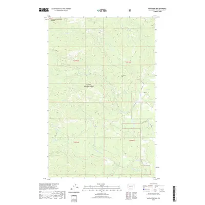
2020 Map of Winchester Peak
USGS Topo · Published 2020About this map
Winchester Peak serves as the central landmark for this mountainous section of Pend Oreille County, where the borders of the Colville National Forest and Kaniksu National Forest converge. The landscape is defined by a dense drainage network, including Small Cr, Winchester Cr, and the N Fork Calispell Cr. These waterways carve through the high elevations of the Selkirk Mountains, influencing the placement of early forest access routes like Flowery Trail Rd and Smalle Creek Rd.
Find a feature on this map
26 named features on this map. Tap any name to fly to it.
Don’t see what you’re looking for? This feature index may not catch every label — zoom into the map to look around manually.
Map Details
Editions of this 2020 Winchester Peak Map
This is the sole edition of this map. No revisions or reprints were ever made.
Other maps of this area

1927 · Chewelah
USGS Topo · 1:125,000

1930 · Chewelah
USGS Topo · 1:125,000

1936 · Newport
USGS Topo · 1:96,000

1942 · Newport
USGS Topo · 1:125,000

1958 · Sandpoint
USGS Topo · 1:250,000

1963 · Sandpoint
USGS Topo · 1:250,000
1964 · Calispell Peak
USGS Topo · 1:24,000

1964 · Goddards Peak
USGS Topo · 1:24,000

1964 · Chewelah Mtn
USGS Topo · 1:62,500
1965 · Nelson Peak
USGS Topo · 1:24,000