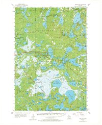
1955 Map of Winchester
USGS Topo · Published 1971About this map
The Northern Highland State Forest dominates this mid-century landscape of the Northwoods, defined by a dense network of glacial lakes and river systems. The settlement of Winchester sits near the upper Turtle River, while further south, Manitowish Waters serves as a central hub for the interconnected water bodies. A distinct cultural and jurisdictional boundary is formed by the Lac Du Flambeau Indian Reservation, which borders the southern marshes and the Chicago and North Western railroad line. Local infrastructure of the era is preserved through landmarks like the Manitowish Waters Landing Field and the Birch Lake Sch. The map also captures the agricultural and industrial nuances of the region, from a Cranberry Bog near Little Trout Lake to the Shea Dam Spillway 1610 on the western edge, providing a look at how water management and tourism-based settlements coexisted before modern expansion.
Find a feature on this map
134 named features on this map. Tap any name to fly to it.
Don’t see what you’re looking for? This feature index may not catch every label — zoom into the map to look around manually.
Map Details
Editions of this 1955 Winchester Map
4 editions found

Other maps of this area

1938 · Minocqua
USGS Topo · 1:48,000

1938 · Lac Du Flambeau
USGS Topo · 1:48,000

1939 · Trout Lake
USGS Topo · 1:48,000

1939 · Lac Du Flambeau
USGS Topo · 1:48,000

1939 · Winchester
USGS Topo · 1:48,000

1940 · Mercer
USGS Topo · 1:48,000

1941 · Pike Lake
USGS Topo · 1:48,000

1942 · Pike Lake
USGS Topo · 1:48,000

1943 · Ironwood
USGS Topo · 1:48,000

1945 · Mercer
USGS Topo · 1:48,000