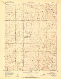
1951 Map of Wind Creek
USGS Topo · Published 1951About this map
Fort Riley Military Reservation dominates the central and southern portions of this landscape, where the tactical needs of the mid-century military intersect with established rural Kansas life. The Military Reservation Boundary cuts through several townships, separating the active vehicle firing range and training grounds from the surrounding civilian farmsteads and school districts. This 1951 edition highlights the educational and spiritual anchors of the community before the expansion of military infrastructure altered the local geography. Local history is preserved through the locations of the Cleveland School, Grant School, and Magic School, alongside the Liberty Cemetery and Vinton Baptist Church. The drainage pattern is defined by the winding paths of Little Arkansas Creek, Wildcat Creek, and Wind Creek, which feed into the larger river systems of the region. Transportation is facilitated by the Chicago Rock Island and Pacific railroad and the Riley County Highway, reflecting the connectivity required for both agriculture and the mobilization of the nearby fort.
Find a feature on this map
23 named features on this map. Tap any name to fly to it.
Don’t see what you’re looking for? This feature index may not catch every label — zoom into the map to look around manually.
Map Details
Editions of this 1951 Wind Creek Map
2 editions found
Other maps of this area

1886 · Junction City
USGS Topo · 1:125,000

1889 · Junction City
USGS Topo · 1:125,000

1894 · Junction City
USGS Topo · 1:125,000

1947 · Manhattan
USGS Topo · 1:62,500

1947 · Fort Riley
USGS Topo · 1:62,500

1950 · Keats
USGS Topo · 1:24,000

1950 · Junction City
USGS Topo · 1:24,000

1950 · Alida
USGS Topo · 1:24,000

1951 · Ogden
USGS Topo · 1:24,000

1951 · Wind Creek
USGS Topo · 1:24,000