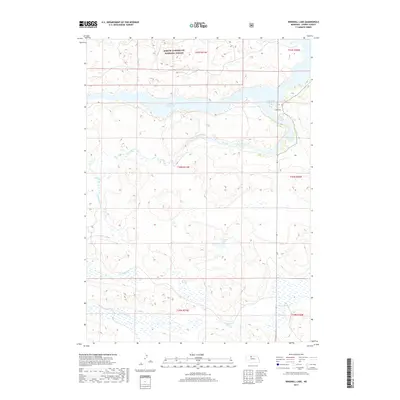
2017 Map of Windmill Lake
USGS Topo · Published 2017About this map
The Samuel R McKelvie National Forest dominates the northern reaches of this Cherry County landscape, preserving a distinct portion of the Nebraska Sandhills. The terrain is defined by an intricate network of hydrology, most notably the expansive Merritt Reservoir and its eastern inlet at Cedar Bay. This area, characterized by its specialized prairie ecosystem and stabilizing vegetation, shows a complex drainage pattern where seasonal wetlands and smaller water bodies like Windmill Lake and Swanson Swamp punctuate the depressions between dunes. Waterways such as Boardman Cr and Gordon Cr meander through the southern half of the quadrangle, illustrating the vital role of surface water in this arid ranching and conservation region. The map captures the interface between managed forest lands and the open, water-dotted plains typical of north-central Nebraska.
Find a feature on this map
13 named features on this map. Tap any name to fly to it.
Don’t see what you’re looking for? This feature index may not catch every label — zoom into the map to look around manually.
Map Details
Editions of this 2017 Windmill Lake Map
This is the sole edition of this map. No revisions or reprints were ever made.
Other maps of this area

1949 · Big Falls
USGS Topo · 1:62,500

1950 · Powderhorn Valley
USGS Topo · 1:62,500

1950 · Kennedy
USGS Topo · 1:62,500

1951 · Big Falls
USGS Topo · 1:62,500

1951 · Bull Lake
USGS Topo · 1:62,500

1957 · Valentine
USGS Topo · 1:250,000

1959 · Valentine
USGS Topo · 1:250,000

1985 · Mullen
USGS Topo · 1:100,000

1985 · Goose Creek
USGS Topo · 1:100,000

1985 · Cody
USGS Topo · 1:100,000