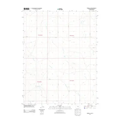
2013 Map of Windmill Lake
USGS Topo · Published 2013About this map
George Lewis Reservoir Number 5 and the namesake Windmill Lake punctuate this high-plains landscape in Crowley County, where water management is central to the land's utility. The terrain is defined by a series of intermittent drainages including Lone Tree Cr, Breckenridge Cr, and Dead Horse Cr that carve subtle patterns across the topography. These seasonal waterways and man-made impoundments reflect the ranching and agricultural requirements of the region during the early 21st century. A rigid grid of section lines and county roads, such as Co Road Aa and Co Road W, provides the primary structure for movement across the open country, illustrating the persistent influence of the Public Land Survey System on the modern Colorado map.
Find a feature on this map
21 named features on this map. Tap any name to fly to it.
Don’t see what you’re looking for? This feature index may not catch every label — zoom into the map to look around manually.
Map Details
Editions of this 2013 Windmill Lake Map
This is the sole edition of this map. No revisions or reprints were ever made.
Other maps of this area

1889 · Sanborn
USGS Topo · 1:125,000

1891 · Sanborn
USGS Topo · 1:125,000

1891 · Catlin
USGS Topo · 1:125,000

1893 · Sanborn
USGS Topo · 1:125,000

1893 · Catlin
USGS Topo · 1:125,000

1954 · Lamar
USGS Topo · 1:250,000

1958 · Lamar
USGS Topo · 1:250,000

1977 · Walker Point
USGS Topo · 1:24,000
1977 · Antelope Mesa
USGS Topo · 1:24,000
1977 · Box Springs
USGS Topo · 1:24,000