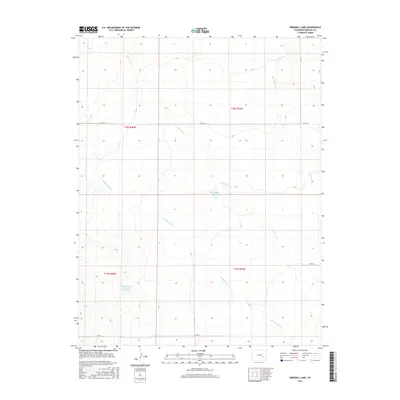
2016 Map of Windmill Lake
USGS Topo · Published 2016About this map
Windmill Lake and the George Lewis Reservoir Number 5 define the hydrology of this Crowley County landscape, which is marked by a network of intermittent stream beds and rural survey lines. The terrain is structured by several significant drainages, including the northward-flowing Lone Tree Cr and the winding Breckenridge Cr, which eventually converge as they move through the plains. The map's grid is defined by the Public Land Survey System, showing the intersection of Townships 18 and 19 South across Ranges 57 and 58 West. This 2016 survey illustrates a sparsely populated agricultural or ranching region where movement is dictated by a rigid section-line road system, including Co Rd AA and Co Rd U. The lack of named settlements emphasizes the rural character of the area, where water management features like reservoirs and the named channels of Dead Horse Cr are the primary landmarks for local navigation and land use.
Find a feature on this map
14 named features on this map. Tap any name to fly to it.
Don’t see what you’re looking for? This feature index may not catch every label — zoom into the map to look around manually.
Map Details
Editions of this 2016 Windmill Lake Map
This is the sole edition of this map. No revisions or reprints were ever made.
Other maps of this area

1889 · Sanborn
USGS Topo · 1:125,000

1891 · Sanborn
USGS Topo · 1:125,000

1891 · Catlin
USGS Topo · 1:125,000

1893 · Sanborn
USGS Topo · 1:125,000

1893 · Catlin
USGS Topo · 1:125,000

1954 · Lamar
USGS Topo · 1:250,000

1958 · Lamar
USGS Topo · 1:250,000

1977 · Walker Point
USGS Topo · 1:24,000
1977 · Antelope Mesa
USGS Topo · 1:24,000
1977 · Box Springs
USGS Topo · 1:24,000