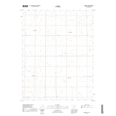
2019 Map of Windmill Lake
USGS Topo · Published 2019About this map
Windmill Lake sits at the center of this Crowley County landscape, serving as a primary water source in a region defined by ephemeral drainages and intermittent creeks. The terrain is carved by the winding paths of Lone Tree Cr and Breckenridge Cr, which converge and traverse the section lines that organize the local ranching and agricultural tracts. Evidence of rural infrastructure is visible in the network of county roads, including Co Rd AA and Co Rd U, which follow the rigid grid of the Public Land Survey System. In the eastern reaches, Dead Horse Cr and Co Ln 17 mark the transition toward neighboring districts, while the southern area is defined by the flow of Bobier. This 2019 survey documents the enduring spatial arrangement of Colorado’s high plains, where water features dictate the placement of local transport routes and land boundaries.
Find a feature on this map
13 named features on this map. Tap any name to fly to it.
Don’t see what you’re looking for? This feature index may not catch every label — zoom into the map to look around manually.
Map Details
Editions of this 2019 Windmill Lake Map
This is the sole edition of this map. No revisions or reprints were ever made.
Other maps of this area

1889 · Sanborn
USGS Topo · 1:125,000

1891 · Sanborn
USGS Topo · 1:125,000

1891 · Catlin
USGS Topo · 1:125,000

1893 · Sanborn
USGS Topo · 1:125,000

1893 · Catlin
USGS Topo · 1:125,000

1954 · Lamar
USGS Topo · 1:250,000

1958 · Lamar
USGS Topo · 1:250,000

1977 · Walker Point
USGS Topo · 1:24,000
1977 · Antelope Mesa
USGS Topo · 1:24,000
1977 · Box Springs
USGS Topo · 1:24,000