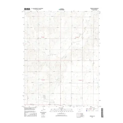
2015 Map of Windom NE
USGS Topo · Published 2015About this map
The rolling plains of western McPherson County are defined by a grid of rural roads and the meandering courses of local waterways. This 2015 U.S. Geological Survey topographic map documents the agricultural landscape where Sharps Cr and its tributary S Sharps Cr cut through the terrain. Evidence of the area's pioneer heritage is visible in the scattered country burial grounds including Excelsior Cem and Fairview Cem, which serve as landmarks for genealogists and local historians. To the south, Windom Cem sits near the headwaters of Blaze Fork. The map's detail provides a record of land management and rural connectivity, with named roads like Quivera Rd and Limestone Rd framing the sections of the Public Land Survey System. Sparse features such as Clear Pond and Edwards Cr further delineate this quiet corner of the Kansas prairie.
Find a feature on this map
30 named features on this map. Tap any name to fly to it.
Don’t see what you’re looking for? This feature index may not catch every label — zoom into the map to look around manually.
Map Details
Editions of this 2015 Windom NE Map
This is the sole edition of this map. No revisions or reprints were ever made.
Other maps of this area

1891 · Hutchinson
USGS Topo · 1:125,000

1892 · Salina
USGS Topo · 1:125,000

1893 · Hutchinson
USGS Topo · 1:125,000

1942 · Salina
USGS Topo · 1:125,000

1955 · Hutchinson
USGS Topo · 1:250,000

1959 · Hutchinson
USGS Topo · 1:250,000

1964 · Marquette
USGS Topo · 1:24,000
1964 · Langley
USGS Topo · 1:24,000

1964 · Windom SW
USGS Topo · 1:24,000

1964 · Conway
USGS Topo · 1:24,000