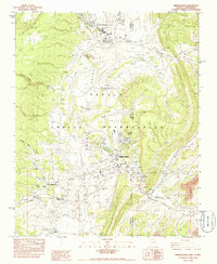
1983 Map of Window Rock
USGS Topo · Published 1986About this map
Navajo Tribal Headquarters serves as the administrative center of the Navajo Indian Reservation in this detailed 1980s provisional survey. The landscape is defined by the convergence of Bonito Creek and Black Creek, where the settlements of Fort Defiance and Window Rock have established deep-rooted institutional presences. Significant cultural and educational sites are distributed throughout the valley, including the St Michaels Indian Sch at Saint Michaels and the Window Rock High Sch.
Find a feature on this map
40 named features on this map. Tap any name to fly to it.
Don’t see what you’re looking for? This feature index may not catch every label — zoom into the map to look around manually.
Map Details
Editions of this 1983 Window Rock Map
2 editions found
Other maps of this area

1886 · Wingate
USGS Topo · 1:250,000

1886 · Fort Defiance
USGS Topo · 1:250,000

1892 · Fort Defiance
USGS Topo · 1:250,000

1892 · Wingate
USGS Topo · 1:250,000

1954 · Gallup
USGS Topo · 1:250,000

1955 · Zith-Tusayan Butte 4 NW
USGS Topo · 1:24,000

1955 · Zith-Tusayan Butte 4 NE
USGS Topo · 1:24,000

1955 · Zith-Tusayan Butte 1 SE
USGS Topo · 1:24,000
1955 · Zith-Tusayan Butte 1 SW
USGS Topo · 1:24,000

1955 · Tohatchi
USGS Topo · 1:62,500
Featured Places
- Fort Defiance Agency
- Fort Defiance, Fort Defiance Agency
- Window Rock, Fort Defiance Agency
- Eastern Navajo Agency, NM
- Saint Michaels, Fort Defiance Agency