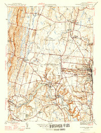
1946 Map of Windsor Locks
USGS Topo · Published 1946About this map
Bradley Field US Military Reservation dominates the central landscape of this mid-century survey, illustrating the significant military footprint in the Connecticut River Valley during the post-war era. To the west, the steep rise of West Suffield Mountain and Peak Mountain provides a sharp geological contrast to the developed lowlands. The area is a dense network of local education and faith, featuring numerous rural schoolhouses like the Boston Neck Sch and Griffin Sch, alongside established institutions such as Suffield Academy. The Farmington River winds through the southern portion, passing through Poquonock and Birchwood, while the New York New Haven and Hartford railroad facilitates industrial movement through Windsor Locks. Notable landmarks include the Old Newgate Prison on the western ridge and a Fish Hatchery near the Windsor Locks town center.
Find a feature on this map
65 named features on this map. Tap any name to fly to it.
Don’t see what you’re looking for? This feature index may not catch every label — zoom into the map to look around manually.
Map Details
Editions of this 1946 Windsor Locks Map
2 editions found
Other maps of this area

1886 · Springfield
USGS Topo · 1:62,500

1887 · Granville
USGS Topo · 1:62,500

1889 · Springfield
USGS Topo · 1:62,500

1889 · Granville
USGS Topo · 1:62,500

1892 · Hartford
USGS Topo · 1:62,500

1892 · Granby
USGS Topo · 1:62,500

1893 · Springfield
USGS Topo · 1:62,500

1893 · Granville
USGS Topo · 1:62,500

1895 · Springfield
USGS Topo · 1:62,500

1895 · Granville
USGS Topo · 1:62,500