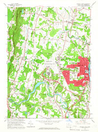
1964 Map of Windsor Locks
USGS Topo · Published 1966About this map
Bradley Field and the adjacent State Dept of Aeronautics dominate the central landscape of this Connecticut River valley survey, reflecting the area's mid-century role in aviation and defense. Along the western ridge, Peak Mountain and the Metacomet Ridge provide a sharp vertical contrast to the industrial and residential core of Windsor Locks. The map details a dense social infrastructure, from the private Suffield Academy and Polish Natl Home to a concentration of religious sites like St Marys Cem and Archer Memorial Ch.
Find a feature on this map
118 named features on this map. Tap any name to fly to it.
Don’t see what you’re looking for? This feature index may not catch every label — zoom into the map to look around manually.
Map Details
Editions of this 1964 Windsor Locks Map
3 editions found
Other maps of this area

1886 · Springfield
USGS Topo · 1:62,500

1887 · Granville
USGS Topo · 1:62,500

1889 · Springfield
USGS Topo · 1:62,500

1889 · Granville
USGS Topo · 1:62,500

1892 · Hartford
USGS Topo · 1:62,500

1892 · Granby
USGS Topo · 1:62,500

1893 · Springfield
USGS Topo · 1:62,500

1893 · Granville
USGS Topo · 1:62,500

1895 · Springfield
USGS Topo · 1:62,500

1895 · Granville
USGS Topo · 1:62,500