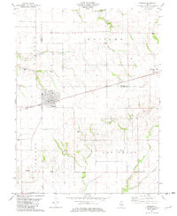
1981 Map of Windsor
USGS Topo · Published 1982About this map
The town of Windsor serves as the primary hub on this central Illinois survey, situated along the Conrail line where the borders of Shelby and Moultrie counties meet. The landscape is defined by the headwaters of several drainages, including Sand Creek and Lynn Creek, which carve gentle valleys through the agricultural upland. For family historians, the map is remarkably dense with burial sites, showing nearly a dozen small grounds like Moberley Cem, Hilligoss Cem, and the Old Lynn Creek Cem.
Find a feature on this map
30 named features on this map. Tap any name to fly to it.
Don’t see what you’re looking for? This feature index may not catch every label — zoom into the map to look around manually.
Map Details
Editions of this 1981 Windsor Map
This is the sole edition of this map. No revisions or reprints were ever made.
Other maps of this area

1934 · Mattoon
USGS Topo · 1:62,500

1935 · Arcola
USGS Topo · 1:48,000

1935 · Sullivan
USGS Topo · 1:48,000

1937 · Mattoon
USGS Topo · 1:62,500

1940 · Sullivan
USGS Topo · 1:62,500

1940 · Arcola
USGS Topo · 1:62,500

1947 · Stewardson
USGS Topo · 1:62,500

1949 · Stewardson
USGS Topo · 1:62,500

1958 · Decatur
USGS Topo · 1:250,000

1961 · Decatur
USGS Topo · 1:250,000