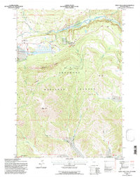
1991 Map of Windy Mountain
USGS Topo · Published 1997About this map
The Chief Joseph Scenic Highway winds through a landscape dominated by the dramatic Cathedral Cliffs and the course of the Clarks Fork Yellowstone River. Located in the northern reaches of the Shoshone National Forest, this 1991 survey shows the area's wilderness character just before the turn of the millennium. The terrain is marked by significant hydrological features like Swamp Lake and several major drainage systems including Reef Creek and Crandall Creek.
Find a feature on this map
34 named features on this map. Tap any name to fly to it.
Don’t see what you’re looking for? This feature index may not catch every label — zoom into the map to look around manually.
Map Details
Editions of this 1991 Windy Mountain Map
This is the sole edition of this map. No revisions or reprints were ever made.
Other maps of this area

1896 · Crandall Creek
USGS Topo · 1:125,000

1899 · Crandall
USGS Topo · 1:125,000

1949 · Pat O'Hara Mountain
USGS Topo · 1:62,500

1950 · Deep Lake
USGS Topo · 1:62,500

1955 · Cody
USGS Topo · 1:250,000

1956 · Beartooth Butte
USGS Topo · 1:62,500

1956 · Dead Indian Peak
USGS Topo · 1:62,500

1958 · Cody
USGS Topo · 1:250,000

1962 · Cody
USGS Topo · 1:250,000

1980 · Cody
USGS Topo · 1:100,000